|
|
|||||||||||||||||
| Point ID: 6794 | Downloads | Plots | Site Data | Code: 10331 |
|
|
|||||||||||||||||
| Download | |
|---|---|
| Site Descriptor Information | Site Time Series Data |
| Link to all available data | |
| View: | Time Series | All |
| Units: | m3/s |
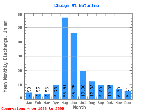
| Statistic | Jan | Feb | Mar | Apr | May | Jun | Jul | Aug | Sep | Oct | Nov | Dec | Annual |
|---|---|---|---|---|---|---|---|---|---|---|---|---|---|
| Mean | 4.58 | 3.58 | 3.56 | 9.73 | 56.90 | 46.25 | 19.80 | 12.33 | 9.80 | 10.09 | 6.90 | 5.71 | 188.47 |
| Standard Deviation | 1.14 | 0.82 | 0.70 | 5.86 | 11.23 | 18.36 | 6.50 | 3.67 | 2.83 | 3.55 | 2.31 | 1.39 | 36.59 |
| Min | 2.39 | 2.18 | 2.29 | 3.36 | 35.37 | 14.54 | 9.30 | 6.77 | 5.54 | 5.34 | 3.88 | 3.48 | 110.96 |
| Max | 7.54 | 5.87 | 5.44 | 29.09 | 84.84 | 112.19 | 37.00 | 23.92 | 17.51 | 19.75 | 13.49 | 9.28 | 260.83 |
| Coefficient of Variation | 0.25 | 0.23 | 0.20 | 0.60 | 0.20 | 0.40 | 0.33 | 0.30 | 0.29 | 0.35 | 0.34 | 0.24 | 0.19 |
 Return to R-Arctic Net Home Page