|
|
|||||||||||||||||
| Point ID: 679 | Downloads | Plots | Site Data | Code: 07BK005 |
|
|
|||||||||||||||||
| Download | |
|---|---|
| Site Descriptor Information | Site Time Series Data |
| Link to all available data | |
| View: | Time Series | All |
| Units: | mm |
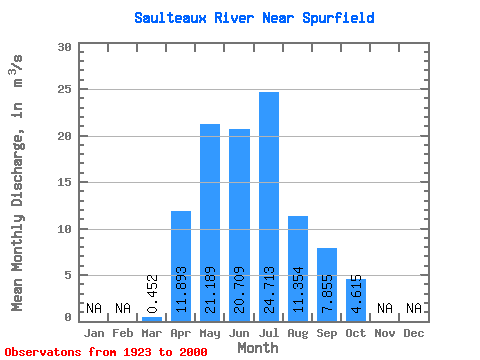
| Statistic | Jan | Feb | Mar | Apr | May | Jun | Jul | Aug | Sep | Oct | Nov | Dec | Annual |
|---|---|---|---|---|---|---|---|---|---|---|---|---|---|
| Mean | 0.45 | 11.89 | 21.19 | 20.71 | 24.71 | 11.35 | 7.86 | 4.62 | |||||
| Standard Deviation | 0.68 | 10.69 | 19.59 | 16.98 | 23.21 | 9.67 | 8.58 | 3.67 | |||||
| Min | 0.02 | 1.68 | 2.38 | 1.76 | 1.63 | 0.34 | 0.23 | 0.31 | |||||
| Max | 3.95 | 53.50 | 98.20 | 74.90 | 88.10 | 49.00 | 40.50 | 14.80 | |||||
| Coefficient of Variation | 1.52 | 0.90 | 0.93 | 0.82 | 0.94 | 0.85 | 1.09 | 0.80 |
 Return to R-Arctic Net Home Page