|
|
|||||||||||||||||
| Point ID: 679 | Downloads | Plots | Site Data | Code: 07BK005 |
|
|
|||||||||||||||||
| Download | |
|---|---|
| Site Descriptor Information | Site Time Series Data |
| Link to all available data | |
| View: | Time Series | All |
| Units: | m3/s |
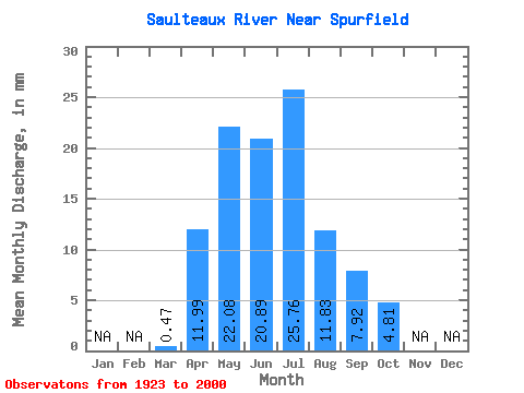
| Statistic | Jan | Feb | Mar | Apr | May | Jun | Jul | Aug | Sep | Oct | Nov | Dec | Annual |
|---|---|---|---|---|---|---|---|---|---|---|---|---|---|
| Mean | 0.47 | 11.86 | 21.82 | 20.64 | 25.45 | 11.69 | 7.83 | 4.75 | |||||
| Standard Deviation | 0.70 | 10.66 | 20.18 | 16.93 | 23.91 | 9.96 | 8.55 | 3.78 | |||||
| Min | 0.02 | 1.68 | 2.45 | 1.75 | 1.68 | 0.35 | 0.23 | 0.32 | |||||
| Max | 4.07 | 53.34 | 101.15 | 74.67 | 90.74 | 50.47 | 40.38 | 15.24 | |||||
| Coefficient of Variation | 1.52 | 0.90 | 0.93 | 0.82 | 0.94 | 0.85 | 1.09 | 0.80 |
 Return to R-Arctic Net Home Page