|
|
|||||||||||||||||
| Point ID: 6789 | Downloads | Plots | Site Data | Code: 10317 |
|
|
|||||||||||||||||
| Download | |
|---|---|
| Site Descriptor Information | Site Time Series Data |
| Link to all available data | |
| View: | Time Series | All |
| Units: | mm |
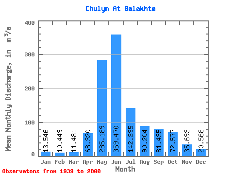
| Statistic | Jan | Feb | Mar | Apr | May | Jun | Jul | Aug | Sep | Oct | Nov | Dec | Annual |
|---|---|---|---|---|---|---|---|---|---|---|---|---|---|
| Mean | 13.55 | 10.45 | 11.48 | 68.32 | 285.19 | 359.47 | 142.40 | 90.20 | 81.44 | 72.58 | 35.69 | 20.57 | 99.59 |
| Standard Deviation | 3.42 | 2.94 | 3.85 | 32.32 | 69.47 | 139.31 | 52.32 | 33.62 | 38.03 | 28.42 | 14.81 | 5.53 | 18.19 |
| Min | 4.73 | 4.61 | 4.83 | 1.00 | 82.60 | 92.30 | 55.00 | 38.50 | 38.00 | 33.00 | 15.00 | 10.20 | 55.23 |
| Max | 19.80 | 16.20 | 23.50 | 153.00 | 512.00 | 679.00 | 305.00 | 244.00 | 253.00 | 190.00 | 98.40 | 33.90 | 139.47 |
| Coefficient of Variation | 0.25 | 0.28 | 0.34 | 0.47 | 0.24 | 0.39 | 0.37 | 0.37 | 0.47 | 0.39 | 0.41 | 0.27 | 0.18 |
 Return to R-Arctic Net Home Page