|
|
|||||||||||||||||
| Point ID: 6789 | Downloads | Plots | Site Data | Code: 10317 |
|
|
|||||||||||||||||
| Download | |
|---|---|
| Site Descriptor Information | Site Time Series Data |
| Link to all available data | |
| View: | Time Series | All |
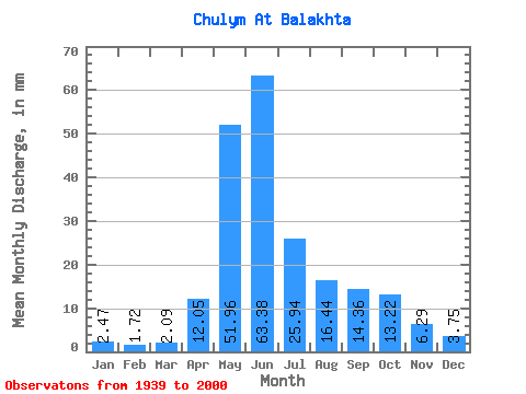
| Units: | m3/s |
| Statistic | Jan | Feb | Mar | Apr | May | Jun | Jul | Aug | Sep | Oct | Nov | Dec | Annual |
|---|---|---|---|---|---|---|---|---|---|---|---|---|---|
| Mean | 2.47 | 1.73 | 2.09 | 12.05 | 51.95 | 63.38 | 25.94 | 16.43 | 14.36 | 13.22 | 6.29 | 3.75 | 213.82 |
| Standard Deviation | 0.62 | 0.49 | 0.70 | 5.70 | 12.65 | 24.56 | 9.53 | 6.12 | 6.71 | 5.18 | 2.61 | 1.01 | 39.05 |
| Min | 0.86 | 0.77 | 0.88 | 0.18 | 15.05 | 16.27 | 10.02 | 7.01 | 6.70 | 6.01 | 2.65 | 1.86 | 118.57 |
| Max | 3.61 | 2.69 | 4.28 | 26.98 | 93.28 | 119.73 | 55.56 | 44.45 | 44.61 | 34.61 | 17.35 | 6.18 | 299.42 |
| Coefficient of Variation | 0.25 | 0.28 | 0.34 | 0.47 | 0.24 | 0.39 | 0.37 | 0.37 | 0.47 | 0.39 | 0.41 | 0.27 | 0.18 |
 Return to R-Arctic Net Home Page