|
|
|||||||||||||||||
| Point ID: 6784 | Downloads | Plots | Site Data | Code: 10305 |
|
|
|||||||||||||||||
| Download | |
|---|---|
| Site Descriptor Information | Site Time Series Data |
| Link to all available data | |
| View: | Time Series | All |
| Units: | mm |
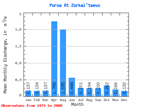
| Statistic | Jan | Feb | Mar | Apr | May | Jun | Jul | Aug | Sep | Oct | Nov | Dec | Annual |
|---|---|---|---|---|---|---|---|---|---|---|---|---|---|
| Mean | 0.14 | 0.13 | 0.14 | 1.79 | 1.59 | 0.45 | 0.20 | 0.19 | 0.20 | 0.26 | 0.17 | 0.13 | 0.45 |
| Standard Deviation | 0.04 | 0.04 | 0.04 | 1.23 | 1.25 | 0.29 | 0.10 | 0.13 | 0.07 | 0.17 | 0.05 | 0.03 | 0.18 |
| Min | 0.07 | 0.07 | 0.07 | 0.29 | 0.19 | 0.05 | 0.07 | 0.07 | 0.10 | 0.10 | 0.09 | 0.05 | 0.22 |
| Max | 0.25 | 0.20 | 0.19 | 4.82 | 4.93 | 1.44 | 0.48 | 0.73 | 0.38 | 0.96 | 0.28 | 0.22 | 0.88 |
| Coefficient of Variation | 0.30 | 0.29 | 0.26 | 0.69 | 0.78 | 0.64 | 0.49 | 0.65 | 0.37 | 0.66 | 0.28 | 0.25 | 0.39 |
 Return to R-Arctic Net Home Page