|
|
|||||||||||||||||
| Point ID: 6784 | Downloads | Plots | Site Data | Code: 10305 |
|
|
|||||||||||||||||
| Download | |
|---|---|
| Site Descriptor Information | Site Time Series Data |
| Link to all available data | |
| View: | Time Series | All |
| Units: | m3/s |
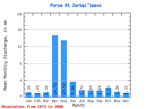
| Statistic | Jan | Feb | Mar | Apr | May | Jun | Jul | Aug | Sep | Oct | Nov | Dec | Annual |
|---|---|---|---|---|---|---|---|---|---|---|---|---|---|
| Mean | 1.16 | 1.04 | 1.16 | 14.73 | 13.51 | 3.66 | 1.71 | 1.64 | 1.64 | 2.22 | 1.36 | 1.12 | 45.01 |
| Standard Deviation | 0.35 | 0.30 | 0.30 | 10.09 | 10.57 | 2.35 | 0.83 | 1.07 | 0.61 | 1.47 | 0.38 | 0.28 | 17.66 |
| Min | 0.57 | 0.53 | 0.55 | 2.38 | 1.61 | 0.39 | 0.58 | 0.63 | 0.82 | 0.85 | 0.73 | 0.41 | 21.81 |
| Max | 2.12 | 1.54 | 1.61 | 39.54 | 41.78 | 11.81 | 4.07 | 6.19 | 3.12 | 8.14 | 2.30 | 1.86 | 87.86 |
| Coefficient of Variation | 0.30 | 0.29 | 0.26 | 0.69 | 0.78 | 0.64 | 0.49 | 0.65 | 0.37 | 0.66 | 0.28 | 0.25 | 0.39 |
 Return to R-Arctic Net Home Page