|
|
|||||||||||||||||
| Point ID: 6756 | Downloads | Plots | Site Data | Code: 10231 |
|
|
|||||||||||||||||
| Download | |
|---|---|
| Site Descriptor Information | Site Time Series Data |
| Link to all available data | |
| View: | Time Series | All |
| Units: | mm |
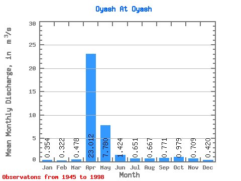
| Statistic | Jan | Feb | Mar | Apr | May | Jun | Jul | Aug | Sep | Oct | Nov | Dec | Annual |
|---|---|---|---|---|---|---|---|---|---|---|---|---|---|
| Mean | 0.35 | 0.32 | 0.48 | 23.01 | 7.78 | 1.42 | 0.65 | 0.67 | 0.77 | 0.98 | 0.71 | 0.42 | 3.13 |
| Standard Deviation | 0.22 | 0.25 | 0.45 | 11.47 | 7.07 | 1.25 | 0.86 | 0.59 | 0.81 | 0.91 | 0.55 | 0.25 | 1.45 |
| Min | 0.06 | 0.01 | 0.01 | 3.07 | 0.72 | 0.22 | 0.06 | 0.03 | 0.02 | 0.03 | 0.14 | 0.03 | 0.86 |
| Max | 0.94 | 1.43 | 2.42 | 48.50 | 37.00 | 6.50 | 5.32 | 2.88 | 4.63 | 4.90 | 2.30 | 1.13 | 7.20 |
| Coefficient of Variation | 0.61 | 0.78 | 0.95 | 0.50 | 0.91 | 0.88 | 1.31 | 0.89 | 1.05 | 0.93 | 0.77 | 0.59 | 0.46 |
 Return to R-Arctic Net Home Page