|
|
|||||||||||||||||
| Point ID: 6756 | Downloads | Plots | Site Data | Code: 10231 |
|
|
|||||||||||||||||
| Download | |
|---|---|
| Site Descriptor Information | Site Time Series Data |
| Link to all available data | |
| View: | Time Series | All |
| Units: | m3/s |
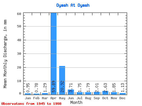
| Statistic | Jan | Feb | Mar | Apr | May | Jun | Jul | Aug | Sep | Oct | Nov | Dec | Annual |
|---|---|---|---|---|---|---|---|---|---|---|---|---|---|
| Mean | 0.95 | 0.79 | 1.29 | 59.89 | 20.92 | 3.71 | 1.75 | 1.79 | 2.01 | 2.63 | 1.85 | 1.13 | 99.25 |
| Standard Deviation | 0.58 | 0.62 | 1.22 | 29.85 | 19.00 | 3.27 | 2.30 | 1.60 | 2.11 | 2.45 | 1.42 | 0.66 | 45.90 |
| Min | 0.16 | 0.02 | 0.04 | 7.99 | 1.94 | 0.57 | 0.15 | 0.07 | 0.06 | 0.08 | 0.36 | 0.08 | 27.22 |
| Max | 2.53 | 3.50 | 6.51 | 126.22 | 99.48 | 16.92 | 14.30 | 7.74 | 12.05 | 13.18 | 5.99 | 3.04 | 228.12 |
| Coefficient of Variation | 0.61 | 0.78 | 0.95 | 0.50 | 0.91 | 0.88 | 1.31 | 0.89 | 1.05 | 0.93 | 0.77 | 0.59 | 0.46 |
 Return to R-Arctic Net Home Page