|
|
|||||||||||||||||
| Point ID: 6733 | Downloads | Plots | Site Data | Code: 10184 |
|
|
|||||||||||||||||
| Download | |
|---|---|
| Site Descriptor Information | Site Time Series Data |
| Link to all available data | |
| View: | Time Series | All |
| Units: | mm |
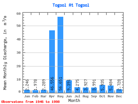
| Statistic | Jan | Feb | Mar | Apr | May | Jun | Jul | Aug | Sep | Oct | Nov | Dec | Annual |
|---|---|---|---|---|---|---|---|---|---|---|---|---|---|
| Mean | 2.25 | 1.98 | 2.29 | 46.56 | 56.65 | 9.39 | 4.28 | 3.93 | 3.99 | 5.94 | 5.48 | 2.73 | 12.06 |
| Standard Deviation | 0.93 | 0.88 | 1.11 | 21.41 | 33.84 | 7.50 | 1.73 | 2.28 | 2.41 | 3.74 | 5.00 | 1.17 | 2.75 |
| Min | 1.08 | 0.68 | 0.93 | 3.90 | 11.20 | 2.67 | 1.65 | 1.44 | 1.50 | 1.95 | 0.01 | 1.01 | 7.29 |
| Max | 5.77 | 5.12 | 7.17 | 83.60 | 144.00 | 35.50 | 9.54 | 13.60 | 16.20 | 17.40 | 32.90 | 6.34 | 18.35 |
| Coefficient of Variation | 0.42 | 0.44 | 0.48 | 0.46 | 0.60 | 0.80 | 0.40 | 0.58 | 0.60 | 0.63 | 0.91 | 0.43 | 0.23 |
 Return to R-Arctic Net Home Page