|
|
|||||||||||||||||
| Point ID: 6733 | Downloads | Plots | Site Data | Code: 10184 |
|
|
|||||||||||||||||
| Download | |
|---|---|
| Site Descriptor Information | Site Time Series Data |
| Link to all available data | |
| View: | Time Series | All |
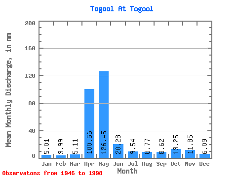
| Units: | m3/s |
| Statistic | Jan | Feb | Mar | Apr | May | Jun | Jul | Aug | Sep | Oct | Nov | Dec | Annual |
|---|---|---|---|---|---|---|---|---|---|---|---|---|---|
| Mean | 5.01 | 4.02 | 5.11 | 100.56 | 126.43 | 20.28 | 9.54 | 8.76 | 8.62 | 13.24 | 11.85 | 6.09 | 317.30 |
| Standard Deviation | 2.08 | 1.79 | 2.47 | 46.26 | 75.53 | 16.21 | 3.86 | 5.08 | 5.20 | 8.36 | 10.79 | 2.62 | 72.24 |
| Min | 2.41 | 1.38 | 2.08 | 8.42 | 25.00 | 5.77 | 3.68 | 3.21 | 3.24 | 4.35 | 0.03 | 2.25 | 191.66 |
| Max | 12.88 | 10.41 | 16.00 | 180.58 | 321.36 | 76.68 | 21.29 | 30.35 | 34.99 | 38.83 | 71.06 | 14.15 | 482.54 |
| Coefficient of Variation | 0.42 | 0.44 | 0.48 | 0.46 | 0.60 | 0.80 | 0.40 | 0.58 | 0.60 | 0.63 | 0.91 | 0.43 | 0.23 |
 Return to R-Arctic Net Home Page