|
|
|||||||||||||||||
| Point ID: 6731 | Downloads | Plots | Site Data | Code: 10180 |
|
|
|||||||||||||||||
| Download | |
|---|---|
| Site Descriptor Information | Site Time Series Data |
| Link to all available data | |
| View: | Time Series | All |
| Units: | mm |
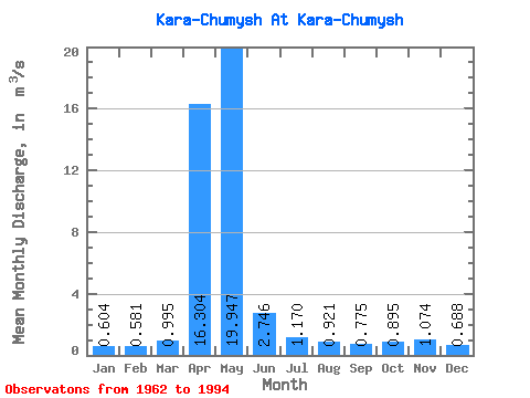
| Statistic | Jan | Feb | Mar | Apr | May | Jun | Jul | Aug | Sep | Oct | Nov | Dec | Annual |
|---|---|---|---|---|---|---|---|---|---|---|---|---|---|
| Mean | 0.60 | 0.58 | 0.99 | 16.30 | 19.95 | 2.75 | 1.17 | 0.92 | 0.78 | 0.90 | 1.07 | 0.69 | 3.89 |
| Standard Deviation | 0.31 | 0.29 | 1.45 | 10.95 | 15.24 | 2.09 | 0.51 | 0.45 | 0.32 | 0.42 | 1.13 | 0.43 | 1.62 |
| Min | 0.15 | 0.15 | 0.23 | 2.33 | 1.44 | 0.44 | 0.27 | 0.31 | 0.37 | 0.32 | 0.30 | 0.17 | 1.41 |
| Max | 1.69 | 1.15 | 8.58 | 47.20 | 65.10 | 7.48 | 2.06 | 2.20 | 1.62 | 2.10 | 6.42 | 2.24 | 7.70 |
| Coefficient of Variation | 0.51 | 0.50 | 1.46 | 0.67 | 0.76 | 0.76 | 0.44 | 0.48 | 0.41 | 0.47 | 1.05 | 0.62 | 0.42 |
 Return to R-Arctic Net Home Page