|
|
|||||||||||||||||
| Point ID: 6731 | Downloads | Plots | Site Data | Code: 10180 |
|
|
|||||||||||||||||
| Download | |
|---|---|
| Site Descriptor Information | Site Time Series Data |
| Link to all available data | |
| View: | Time Series | All |
| Units: | m3/s |
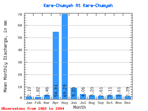
| Statistic | Jan | Feb | Mar | Apr | May | Jun | Jul | Aug | Sep | Oct | Nov | Dec | Annual |
|---|---|---|---|---|---|---|---|---|---|---|---|---|---|
| Mean | 2.10 | 1.84 | 3.45 | 54.81 | 69.28 | 9.23 | 4.06 | 3.20 | 2.60 | 3.11 | 3.61 | 2.39 | 159.31 |
| Standard Deviation | 1.07 | 0.92 | 5.03 | 36.80 | 52.94 | 7.03 | 1.79 | 1.54 | 1.07 | 1.48 | 3.79 | 1.48 | 66.25 |
| Min | 0.52 | 0.47 | 0.80 | 7.83 | 5.00 | 1.48 | 0.94 | 1.08 | 1.24 | 1.11 | 1.01 | 0.59 | 57.51 |
| Max | 5.87 | 3.64 | 29.80 | 158.68 | 226.12 | 25.15 | 7.16 | 7.64 | 5.45 | 7.29 | 21.58 | 7.78 | 315.09 |
| Coefficient of Variation | 0.51 | 0.50 | 1.46 | 0.67 | 0.76 | 0.76 | 0.44 | 0.48 | 0.41 | 0.47 | 1.05 | 0.62 | 0.42 |
 Return to R-Arctic Net Home Page