|
|
|||||||||||||||||
| Point ID: 671 | Downloads | Plots | Site Data | Code: 07BH003 |
|
|
|||||||||||||||||
| Download | |
|---|---|
| Site Descriptor Information | Site Time Series Data |
| Link to all available data | |
| View: | Time Series | All |
| Units: | mm |
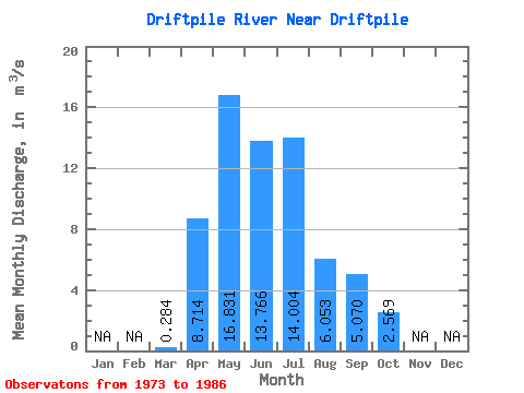
| Statistic | Jan | Feb | Mar | Apr | May | Jun | Jul | Aug | Sep | Oct | Nov | Dec | Annual |
|---|---|---|---|---|---|---|---|---|---|---|---|---|---|
| Mean | 0.28 | 8.71 | 16.83 | 13.77 | 14.00 | 6.05 | 5.07 | 2.57 | |||||
| Standard Deviation | 0.14 | 6.72 | 8.97 | 8.91 | 11.62 | 7.30 | 4.16 | 2.23 | |||||
| Min | 0.04 | 1.17 | 2.12 | 1.55 | 1.76 | 0.57 | 0.44 | 0.62 | |||||
| Max | 0.48 | 25.50 | 30.30 | 28.10 | 36.60 | 27.60 | 14.40 | 7.62 | |||||
| Coefficient of Variation | 0.48 | 0.77 | 0.53 | 0.65 | 0.83 | 1.21 | 0.82 | 0.87 |
 Return to R-Arctic Net Home Page