|
|
|||||||||||||||||
| Point ID: 671 | Downloads | Plots | Site Data | Code: 07BH003 |
|
|
|||||||||||||||||
| Download | |
|---|---|
| Site Descriptor Information | Site Time Series Data |
| Link to all available data | |
| View: | Time Series | All |
| Units: | m3/s |
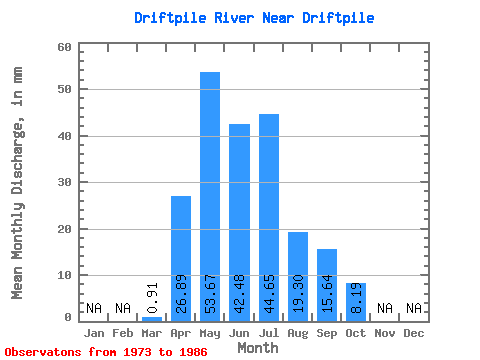
| Statistic | Jan | Feb | Mar | Apr | May | Jun | Jul | Aug | Sep | Oct | Nov | Dec | Annual |
|---|---|---|---|---|---|---|---|---|---|---|---|---|---|
| Mean | 0.91 | 26.89 | 53.66 | 42.48 | 44.65 | 19.30 | 15.64 | 8.19 | |||||
| Standard Deviation | 0.44 | 20.73 | 28.59 | 27.50 | 37.04 | 23.27 | 12.84 | 7.13 | |||||
| Min | 0.12 | 3.61 | 6.76 | 4.78 | 5.61 | 1.81 | 1.36 | 1.97 | |||||
| Max | 1.55 | 78.69 | 96.60 | 86.71 | 116.68 | 87.99 | 44.43 | 24.29 | |||||
| Coefficient of Variation | 0.48 | 0.77 | 0.53 | 0.65 | 0.83 | 1.21 | 0.82 | 0.87 |
 Return to R-Arctic Net Home Page