|
|
|||||||||||||||||
| Point ID: 6678 | Downloads | Plots | Site Data | Code: 10060 |
|
|
|||||||||||||||||
| Download | |
|---|---|
| Site Descriptor Information | Site Time Series Data |
| Link to all available data | |
| View: | Time Series | All |
| Units: | mm |
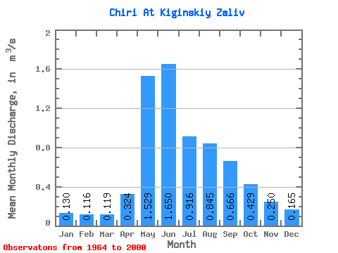
| Statistic | Jan | Feb | Mar | Apr | May | Jun | Jul | Aug | Sep | Oct | Nov | Dec | Annual |
|---|---|---|---|---|---|---|---|---|---|---|---|---|---|
| Mean | 0.13 | 0.12 | 0.12 | 0.32 | 1.53 | 1.65 | 0.92 | 0.84 | 0.67 | 0.43 | 0.25 | 0.17 | 0.59 |
| Standard Deviation | 0.03 | 0.03 | 0.02 | 0.16 | 0.57 | 0.93 | 0.39 | 0.41 | 0.24 | 0.11 | 0.06 | 0.04 | 0.11 |
| Min | 0.07 | 0.07 | 0.08 | 0.10 | 0.82 | 0.52 | 0.40 | 0.24 | 0.22 | 0.22 | 0.15 | 0.07 | 0.31 |
| Max | 0.18 | 0.19 | 0.17 | 0.99 | 3.40 | 4.74 | 1.95 | 1.91 | 1.14 | 0.71 | 0.40 | 0.23 | 0.80 |
| Coefficient of Variation | 0.22 | 0.24 | 0.20 | 0.49 | 0.38 | 0.56 | 0.42 | 0.48 | 0.36 | 0.26 | 0.24 | 0.25 | 0.19 |
 Return to R-Arctic Net Home Page