|
|
|||||||||||||||||
| Point ID: 6678 | Downloads | Plots | Site Data | Code: 10060 |
|
|
|||||||||||||||||
| Download | |
|---|---|
| Site Descriptor Information | Site Time Series Data |
| Link to all available data | |
| View: | Time Series | All |
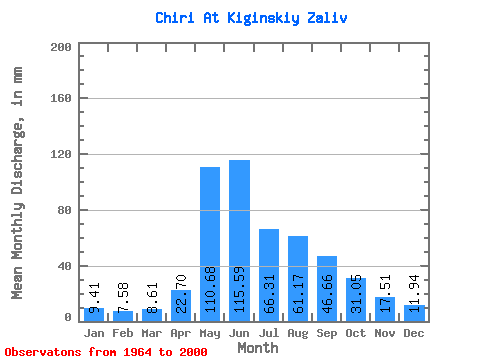
| Units: | m3/s |
| Statistic | Jan | Feb | Mar | Apr | May | Jun | Jul | Aug | Sep | Oct | Nov | Dec | Annual |
|---|---|---|---|---|---|---|---|---|---|---|---|---|---|
| Mean | 9.37 | 7.63 | 8.61 | 22.68 | 110.67 | 115.59 | 66.31 | 61.16 | 46.69 | 31.04 | 17.49 | 11.95 | 507.40 |
| Standard Deviation | 2.08 | 1.85 | 1.75 | 11.20 | 41.62 | 64.90 | 27.93 | 29.51 | 16.95 | 7.98 | 4.18 | 3.04 | 95.39 |
| Min | 5.28 | 4.42 | 5.50 | 6.79 | 59.35 | 36.43 | 28.95 | 17.37 | 15.41 | 15.92 | 10.51 | 4.78 | 264.92 |
| Max | 13.03 | 12.53 | 12.30 | 69.35 | 246.09 | 332.06 | 141.14 | 138.24 | 79.86 | 51.39 | 28.02 | 16.65 | 683.09 |
| Coefficient of Variation | 0.22 | 0.24 | 0.20 | 0.49 | 0.38 | 0.56 | 0.42 | 0.48 | 0.36 | 0.26 | 0.24 | 0.25 | 0.19 |
 Return to R-Arctic Net Home Page