|
|
|||||||||||||||||
| Point ID: 6664 | Downloads | Plots | Site Data | Code: 10021 |
|
|
|||||||||||||||||
| Download | |
|---|---|
| Site Descriptor Information | Site Time Series Data |
| Link to all available data | |
| View: | Time Series | All |
| Units: | mm |
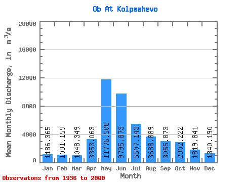
| Statistic | Jan | Feb | Mar | Apr | May | Jun | Jul | Aug | Sep | Oct | Nov | Dec | Annual |
|---|---|---|---|---|---|---|---|---|---|---|---|---|---|
| Mean | 1186.37 | 1091.16 | 1048.35 | 3353.06 | 11776.51 | 9795.87 | 5507.14 | 3688.89 | 3055.87 | 2902.22 | 1819.84 | 1340.19 | 3880.46 |
| Standard Deviation | 211.72 | 217.55 | 208.42 | 1557.36 | 2374.09 | 3312.33 | 1988.37 | 1114.33 | 833.74 | 769.52 | 518.13 | 223.56 | 717.50 |
| Min | 764.00 | 752.00 | 693.00 | 918.00 | 7080.00 | 4860.00 | 2670.00 | 2110.00 | 1840.00 | 1670.00 | 1060.00 | 990.00 | 2690.25 |
| Max | 1830.00 | 1670.00 | 1550.00 | 7390.00 | 18600.00 | 19700.00 | 9560.00 | 7550.00 | 5200.00 | 5360.00 | 3000.00 | 1940.00 | 5643.83 |
| Coefficient of Variation | 0.18 | 0.20 | 0.20 | 0.46 | 0.20 | 0.34 | 0.36 | 0.30 | 0.27 | 0.27 | 0.28 | 0.17 | 0.18 |
 Return to R-Arctic Net Home Page