|
|
|||||||||||||||||
| Point ID: 6664 | Downloads | Plots | Site Data | Code: 10021 |
|
|
|||||||||||||||||
| Download | |
|---|---|
| Site Descriptor Information | Site Time Series Data |
| Link to all available data | |
| View: | Time Series | All |
| Units: | m3/s |
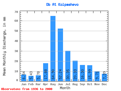
| Statistic | Jan | Feb | Mar | Apr | May | Jun | Jul | Aug | Sep | Oct | Nov | Dec | Annual |
|---|---|---|---|---|---|---|---|---|---|---|---|---|---|
| Mean | 6.54 | 5.48 | 5.78 | 17.88 | 64.89 | 52.24 | 30.35 | 20.33 | 16.30 | 15.99 | 9.71 | 7.38 | 251.99 |
| Standard Deviation | 1.17 | 1.09 | 1.15 | 8.31 | 13.08 | 17.67 | 10.96 | 6.14 | 4.45 | 4.24 | 2.76 | 1.23 | 46.59 |
| Min | 4.21 | 3.77 | 3.82 | 4.90 | 39.01 | 25.92 | 14.71 | 11.63 | 9.81 | 9.20 | 5.65 | 5.46 | 174.70 |
| Max | 10.08 | 8.38 | 8.54 | 39.41 | 102.49 | 105.07 | 52.68 | 41.60 | 27.73 | 29.54 | 16.00 | 10.69 | 366.50 |
| Coefficient of Variation | 0.18 | 0.20 | 0.20 | 0.46 | 0.20 | 0.34 | 0.36 | 0.30 | 0.27 | 0.27 | 0.28 | 0.17 | 0.18 |
 Return to R-Arctic Net Home Page