|
|
|||||||||||||||||
| Point ID: 6662 | Downloads | Plots | Site Data | Code: 10015 |
|
|
|||||||||||||||||
| Download | |
|---|---|
| Site Descriptor Information | Site Time Series Data |
| Link to all available data | |
| View: | Time Series | All |
| Units: | mm |
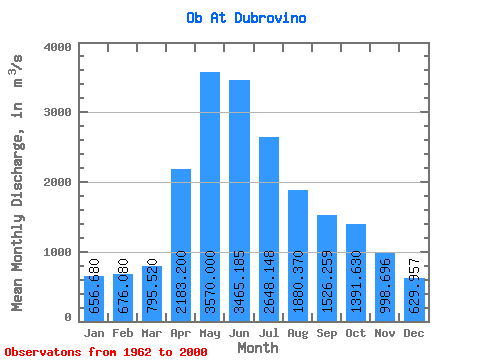
| Statistic | Jan | Feb | Mar | Apr | May | Jun | Jul | Aug | Sep | Oct | Nov | Dec | Annual |
|---|---|---|---|---|---|---|---|---|---|---|---|---|---|
| Mean | 656.68 | 676.08 | 795.52 | 2183.20 | 3570.00 | 3465.18 | 2648.15 | 1880.37 | 1526.26 | 1391.63 | 998.70 | 629.96 | 1695.54 |
| Standard Deviation | 171.59 | 163.65 | 146.27 | 647.58 | 1220.98 | 1107.97 | 963.18 | 525.57 | 356.33 | 346.68 | 229.67 | 121.69 | 281.63 |
| Min | 421.00 | 397.00 | 501.00 | 1170.00 | 2050.00 | 2000.00 | 1540.00 | 1130.00 | 916.00 | 846.00 | 599.00 | 442.00 | 1246.25 |
| Max | 1250.00 | 1070.00 | 1060.00 | 3640.00 | 7620.00 | 6660.00 | 5300.00 | 3170.00 | 2380.00 | 2170.00 | 1610.00 | 861.00 | 2408.17 |
| Coefficient of Variation | 0.26 | 0.24 | 0.18 | 0.30 | 0.34 | 0.32 | 0.36 | 0.28 | 0.23 | 0.25 | 0.23 | 0.19 | 0.17 |
 Return to R-Arctic Net Home Page