|
|
|||||||||||||||||
| Point ID: 6662 | Downloads | Plots | Site Data | Code: 10015 |
|
|
|||||||||||||||||
| Download | |
|---|---|
| Site Descriptor Information | Site Time Series Data |
| Link to all available data | |
| View: | Time Series | All |
| Units: | m3/s |
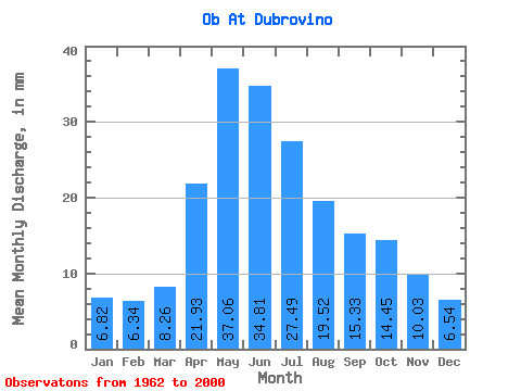
| Statistic | Jan | Feb | Mar | Apr | May | Jun | Jul | Aug | Sep | Oct | Nov | Dec | Annual |
|---|---|---|---|---|---|---|---|---|---|---|---|---|---|
| Mean | 6.82 | 6.39 | 8.26 | 21.93 | 37.06 | 34.81 | 27.49 | 19.52 | 15.33 | 14.45 | 10.03 | 6.54 | 207.41 |
| Standard Deviation | 1.78 | 1.55 | 1.52 | 6.51 | 12.67 | 11.13 | 10.00 | 5.46 | 3.58 | 3.60 | 2.31 | 1.26 | 34.45 |
| Min | 4.37 | 3.75 | 5.20 | 11.75 | 21.28 | 20.09 | 15.98 | 11.73 | 9.20 | 8.78 | 6.02 | 4.59 | 152.45 |
| Max | 12.97 | 10.12 | 11.00 | 36.57 | 79.09 | 66.91 | 55.01 | 32.90 | 23.91 | 22.52 | 16.18 | 8.94 | 294.58 |
| Coefficient of Variation | 0.26 | 0.24 | 0.18 | 0.30 | 0.34 | 0.32 | 0.36 | 0.28 | 0.23 | 0.25 | 0.23 | 0.19 | 0.17 |
 Return to R-Arctic Net Home Page