|
|
|||||||||||||||||
| Point ID: 6661 | Downloads | Plots | Site Data | Other Close Sites | Code: 10014 |
|
|
|||||||||||||||||
| Download | |
|---|---|
| Site Descriptor Information | Site Time Series Data |
| Link to all available data | |
| View: | Time Series | All |
| Units: | mm |
| Statistic | Jan | Feb | Mar | Apr | May | Jun | Jul | Aug | Sep | Oct | Nov | Dec | Annual |
|---|---|---|---|---|---|---|---|---|---|---|---|---|---|
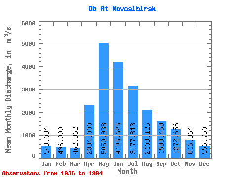
| Mean | 543.03 | 496.00 | 462.86 | 2334.00 | 5050.94 | 4195.62 | 3177.81 | 2108.12 | 1593.47 | 1272.66 | 816.96 | 556.75 | 1915.51 |
| Standard Deviation | 247.38 | 284.29 | 270.16 | 1075.29 | 1507.76 | 1169.78 | 1185.74 | 644.94 | 511.70 | 406.04 | 323.75 | 121.25 | 349.60 |
| Min | 267.00 | 259.00 | 213.00 | 594.00 | 2980.00 | 2090.00 | 1370.00 | 1220.00 | 869.00 | 686.00 | 444.00 | 340.00 | 1208.33 |
| Max | 1380.00 | 1300.00 | 1310.00 | 5100.00 | 9480.00 | 6240.00 | 5490.00 | 3970.00 | 3000.00 | 2660.00 | 1510.00 | 768.00 | 2563.92 |
| Coefficient of Variation | 0.46 | 0.57 | 0.58 | 0.46 | 0.30 | 0.28 | 0.37 | 0.31 | 0.32 | 0.32 | 0.40 | 0.22 | 0.18 |
| Other Close Sites | ||||||
|---|---|---|---|---|---|---|
| PointID | Latitude | Longitude | Drainage Area | Source | Name | |
| 6660 | "Ob At HPS Novosibirskaya" | 54.80 | -472892 | SHI | 2986.00 | |
| 6752 | "Inya (Nyzhnyaya) At Berezovka" | 55.00 | -445058 | SHI | 35.00 | |
 Return to R-Arctic Net Home Page