|
|
|||||||||||||||||
| Point ID: 6660 | Downloads | Plots | Site Data | Other Close Sites | Code: 10011 |
|
|
|||||||||||||||||
| Download | |
|---|---|
| Site Descriptor Information | Site Time Series Data |
| Link to all available data | |
| View: | Time Series | All |
| Units: | mm |
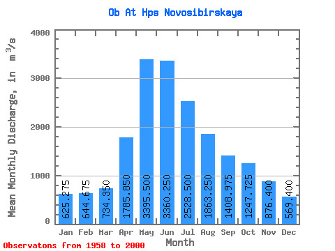
| Statistic | Jan | Feb | Mar | Apr | May | Jun | Jul | Aug | Sep | Oct | Nov | Dec | Annual |
|---|---|---|---|---|---|---|---|---|---|---|---|---|---|
| Mean | 625.27 | 644.67 | 734.35 | 1785.85 | 3395.50 | 3360.25 | 2528.50 | 1863.25 | 1408.97 | 1247.72 | 876.40 | 569.40 | 1586.68 |
| Standard Deviation | 141.24 | 142.48 | 138.88 | 623.02 | 1179.69 | 1078.64 | 946.68 | 653.16 | 298.47 | 295.32 | 176.33 | 101.40 | 302.82 |
| Min | 438.00 | 446.00 | 428.00 | 829.00 | 1870.00 | 1840.00 | 1330.00 | 1170.00 | 914.00 | 792.00 | 560.00 | 436.00 | 1156.83 |
| Max | 1120.00 | 983.00 | 1110.00 | 3080.00 | 6920.00 | 7000.00 | 5000.00 | 3950.00 | 2120.00 | 2000.00 | 1240.00 | 915.00 | 2329.42 |
| Coefficient of Variation | 0.23 | 0.22 | 0.19 | 0.35 | 0.35 | 0.32 | 0.37 | 0.35 | 0.21 | 0.24 | 0.20 | 0.18 | 0.19 |
| Other Close Sites | ||||||
|---|---|---|---|---|---|---|
| PointID | Latitude | Longitude | Drainage Area | Source | Name | |
| 6661 | "Ob At Novosibirsk" | 55.00 | -470289 | SHI | 2963.00 | |
| 6752 | "Inya (Nyzhnyaya) At Berezovka" | 55.00 | -445058 | SHI | 35.00 | |
 Return to R-Arctic Net Home Page