|
|
|||||||||||||||||
| Point ID: 6654 | Downloads | Plots | Site Data | Code: 9543 |
|
|
|||||||||||||||||
| Download | |
|---|---|
| Site Descriptor Information | Site Time Series Data |
| Link to all available data | |
| View: | Time Series | All |
| Units: | mm |
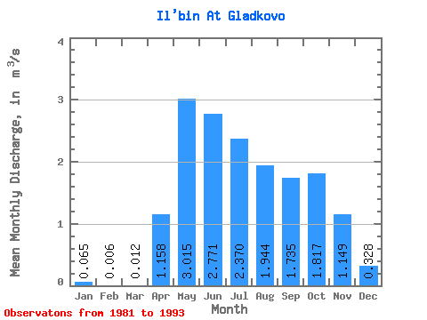
| Statistic | Jan | Feb | Mar | Apr | May | Jun | Jul | Aug | Sep | Oct | Nov | Dec | Annual |
|---|---|---|---|---|---|---|---|---|---|---|---|---|---|
| Mean | 0.07 | 0.01 | 0.01 | 1.16 | 3.02 | 2.77 | 2.37 | 1.94 | 1.73 | 1.82 | 1.15 | 0.33 | 1.57 |
| Standard Deviation | 0.14 | 0.01 | 0.03 | 0.74 | 1.21 | 1.15 | 1.12 | 1.06 | 0.87 | 1.00 | 0.47 | 0.31 | 0.53 |
| Min | 0.00 | 0.00 | 0.00 | 0.31 | 1.68 | 1.46 | 1.25 | 0.93 | 0.84 | 0.90 | 0.68 | 0.02 | 0.84 |
| Max | 0.42 | 0.04 | 0.06 | 2.69 | 4.89 | 5.11 | 4.08 | 4.68 | 3.36 | 4.45 | 2.12 | 0.89 | 2.10 |
| Coefficient of Variation | 2.10 | 2.45 | 2.24 | 0.64 | 0.40 | 0.41 | 0.47 | 0.55 | 0.50 | 0.55 | 0.41 | 0.93 | 0.34 |
 Return to R-Arctic Net Home Page