|
|
|||||||||||||||||
| Point ID: 6654 | Downloads | Plots | Site Data | Code: 9543 |
|
|
|||||||||||||||||
| Download | |
|---|---|
| Site Descriptor Information | Site Time Series Data |
| Link to all available data | |
| View: | Time Series | All |
| Units: | m3/s |
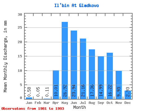
| Statistic | Jan | Feb | Mar | Apr | May | Jun | Jul | Aug | Sep | Oct | Nov | Dec | Annual |
|---|---|---|---|---|---|---|---|---|---|---|---|---|---|
| Mean | 0.58 | 0.05 | 0.11 | 10.01 | 26.91 | 23.94 | 21.16 | 17.35 | 14.99 | 16.22 | 9.93 | 2.93 | 165.56 |
| Standard Deviation | 1.21 | 0.12 | 0.24 | 6.37 | 10.76 | 9.92 | 10.01 | 9.49 | 7.55 | 8.97 | 4.05 | 2.73 | 55.94 |
| Min | 0.00 | 0.00 | 0.00 | 2.68 | 15.00 | 12.61 | 11.16 | 8.30 | 7.26 | 8.03 | 5.88 | 0.15 | 88.06 |
| Max | 3.75 | 0.29 | 0.54 | 23.24 | 43.65 | 44.15 | 36.42 | 41.78 | 29.03 | 39.72 | 18.32 | 7.95 | 220.48 |
| Coefficient of Variation | 2.10 | 2.45 | 2.24 | 0.64 | 0.40 | 0.41 | 0.47 | 0.55 | 0.50 | 0.55 | 0.41 | 0.93 | 0.34 |
 Return to R-Arctic Net Home Page