|
|
|||||||||||||||||
| Point ID: 6649 | Downloads | Plots | Site Data | Code: 9517 |
|
|
|||||||||||||||||
| Download | |
|---|---|
| Site Descriptor Information | Site Time Series Data |
| Link to all available data | |
| View: | Time Series | All |
| Units: | mm |
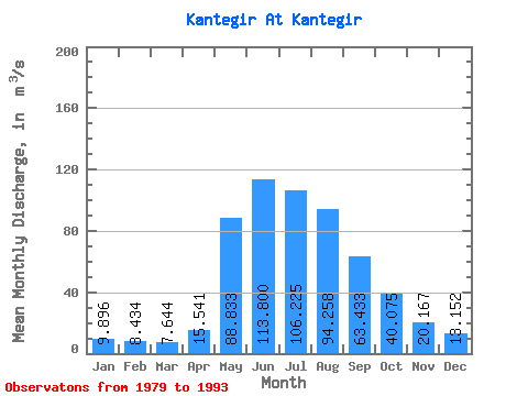
| Statistic | Jan | Feb | Mar | Apr | May | Jun | Jul | Aug | Sep | Oct | Nov | Dec | Annual |
|---|---|---|---|---|---|---|---|---|---|---|---|---|---|
| Mean | 9.90 | 8.43 | 7.64 | 15.54 | 88.83 | 113.80 | 106.22 | 94.26 | 63.43 | 40.08 | 20.17 | 13.15 | 48.75 |
| Standard Deviation | 2.63 | 1.04 | 1.65 | 6.79 | 23.28 | 36.60 | 30.42 | 48.31 | 20.71 | 13.63 | 3.44 | 3.54 | 9.06 |
| Min | 5.09 | 6.67 | 5.55 | 8.67 | 59.90 | 58.50 | 45.10 | 39.10 | 26.40 | 21.50 | 12.80 | 6.61 | 34.99 |
| Max | 13.70 | 10.00 | 11.70 | 27.90 | 140.00 | 216.00 | 157.00 | 215.00 | 99.40 | 67.20 | 25.60 | 20.30 | 67.93 |
| Coefficient of Variation | 0.27 | 0.12 | 0.22 | 0.44 | 0.26 | 0.32 | 0.29 | 0.51 | 0.33 | 0.34 | 0.17 | 0.27 | 0.19 |
 Return to R-Arctic Net Home Page