|
|
|||||||||||||||||
| Point ID: 6649 | Downloads | Plots | Site Data | Code: 9517 |
|
|
|||||||||||||||||
| Download | |
|---|---|
| Site Descriptor Information | Site Time Series Data |
| Link to all available data | |
| View: | Time Series | All |
| Units: | m3/s |
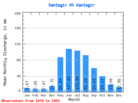
| Statistic | Jan | Feb | Mar | Apr | May | Jun | Jul | Aug | Sep | Oct | Nov | Dec | Annual |
|---|---|---|---|---|---|---|---|---|---|---|---|---|---|
| Mean | 9.67 | 7.51 | 7.47 | 14.70 | 86.82 | 107.65 | 103.82 | 92.12 | 60.01 | 39.17 | 19.08 | 12.86 | 561.49 |
| Standard Deviation | 2.57 | 0.93 | 1.61 | 6.42 | 22.75 | 34.63 | 29.73 | 47.22 | 19.59 | 13.32 | 3.25 | 3.46 | 104.34 |
| Min | 4.97 | 5.94 | 5.42 | 8.20 | 58.55 | 55.34 | 44.08 | 38.22 | 24.97 | 21.01 | 12.11 | 6.46 | 402.98 |
| Max | 13.39 | 8.90 | 11.44 | 26.39 | 136.83 | 204.33 | 153.45 | 210.13 | 94.03 | 65.68 | 24.22 | 19.84 | 782.42 |
| Coefficient of Variation | 0.27 | 0.12 | 0.22 | 0.44 | 0.26 | 0.32 | 0.29 | 0.51 | 0.33 | 0.34 | 0.17 | 0.27 | 0.19 |
 Return to R-Arctic Net Home Page