|
|
|||||||||||||||||
| Point ID: 6639 | Downloads | Plots | Site Data | Code: 9495 |
|
|
|||||||||||||||||
| Download | |
|---|---|
| Site Descriptor Information | Site Time Series Data |
| Link to all available data | |
| View: | Time Series | All |
| Units: | mm |
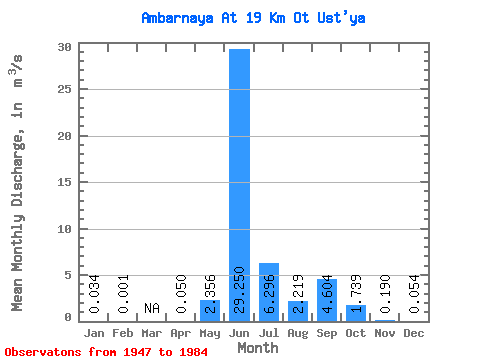
| Statistic | Jan | Feb | Mar | Apr | May | Jun | Jul | Aug | Sep | Oct | Nov | Dec | Annual |
|---|---|---|---|---|---|---|---|---|---|---|---|---|---|
| Mean | 0.03 | 0.00 | 0.05 | 2.36 | 29.25 | 6.30 | 2.22 | 4.60 | 1.74 | 0.19 | 0.05 | ||
| Standard Deviation | 0.04 | 0.01 | 3.00 | 6.65 | 4.31 | 1.51 | 2.16 | 1.98 | 0.13 | 0.06 | |||
| Min | 0.00 | 0.00 | 0.04 | 0.09 | 16.50 | 1.77 | 0.38 | 1.14 | 0.32 | 0.01 | 0.00 | ||
| Max | 0.06 | 0.00 | 0.06 | 8.66 | 46.80 | 18.40 | 5.26 | 8.81 | 8.27 | 0.58 | 0.23 | ||
| Coefficient of Variation | 1.25 | 0.27 | 1.27 | 0.23 | 0.69 | 0.68 | 0.47 | 1.14 | 0.66 | 1.05 |
 Return to R-Arctic Net Home Page