|
|
|||||||||||||||||
| Point ID: 6639 | Downloads | Plots | Site Data | Code: 9495 |
|
|
|||||||||||||||||
| Download | |
|---|---|
| Site Descriptor Information | Site Time Series Data |
| Link to all available data | |
| View: | Time Series | All |
| Units: | m3/s |
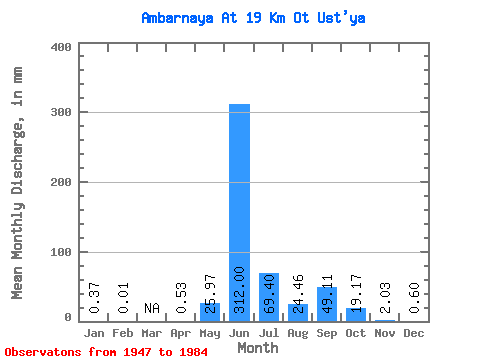
| Statistic | Jan | Feb | Mar | Apr | May | Jun | Jul | Aug | Sep | Oct | Nov | Dec | Annual |
|---|---|---|---|---|---|---|---|---|---|---|---|---|---|
| Mean | 0.37 | 0.01 | 0.54 | 25.96 | 312.00 | 69.38 | 24.46 | 49.11 | 19.16 | 2.03 | 0.59 | ||
| Standard Deviation | 0.46 | 0.14 | 33.08 | 70.97 | 47.54 | 16.61 | 23.05 | 21.82 | 1.35 | 0.62 | |||
| Min | 0.04 | 0.01 | 0.44 | 0.94 | 176.00 | 19.51 | 4.19 | 12.16 | 3.53 | 0.10 | 0.03 | ||
| Max | 0.69 | 0.01 | 0.64 | 95.44 | 499.20 | 202.78 | 57.97 | 93.97 | 91.14 | 6.19 | 2.54 | ||
| Coefficient of Variation | 1.25 | 0.27 | 1.27 | 0.23 | 0.69 | 0.68 | 0.47 | 1.14 | 0.66 | 1.05 |
 Return to R-Arctic Net Home Page