|
|
|||||||||||||||||
| Point ID: 6632 | Downloads | Plots | Site Data | Code: 9425 |
|
|
|||||||||||||||||
| Download | |
|---|---|
| Site Descriptor Information | Site Time Series Data |
| Link to all available data | |
| View: | Time Series | All |
| Units: | mm |
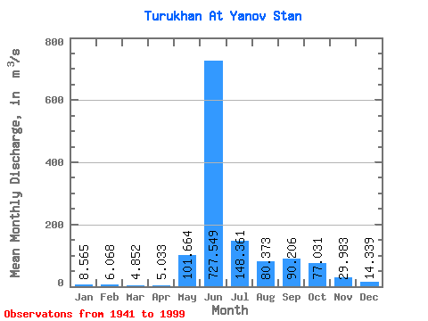
| Statistic | Jan | Feb | Mar | Apr | May | Jun | Jul | Aug | Sep | Oct | Nov | Dec | Annual |
|---|---|---|---|---|---|---|---|---|---|---|---|---|---|
| Mean | 8.56 | 6.07 | 4.85 | 5.03 | 101.66 | 727.55 | 148.36 | 80.37 | 90.21 | 77.03 | 29.98 | 14.34 | 107.64 |
| Standard Deviation | 3.10 | 2.44 | 2.16 | 3.14 | 136.58 | 198.03 | 69.72 | 39.96 | 46.93 | 40.19 | 16.17 | 7.17 | 17.53 |
| Min | 3.58 | 1.90 | 1.45 | 1.88 | 4.55 | 292.00 | 53.20 | 24.10 | 11.60 | 10.70 | 5.49 | 4.11 | 67.07 |
| Max | 17.80 | 13.30 | 12.40 | 21.30 | 622.00 | 1160.00 | 452.00 | 198.00 | 213.00 | 189.00 | 95.50 | 44.30 | 147.03 |
| Coefficient of Variation | 0.36 | 0.40 | 0.44 | 0.62 | 1.34 | 0.27 | 0.47 | 0.50 | 0.52 | 0.52 | 0.54 | 0.50 | 0.16 |
 Return to R-Arctic Net Home Page