|
|
|||||||||||||||||
| Point ID: 6632 | Downloads | Plots | Site Data | Code: 9425 |
|
|
|||||||||||||||||
| Download | |
|---|---|
| Site Descriptor Information | Site Time Series Data |
| Link to all available data | |
| View: | Time Series | All |
| Units: | m3/s |
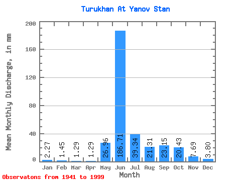
| Statistic | Jan | Feb | Mar | Apr | May | Jun | Jul | Aug | Sep | Oct | Nov | Dec | Annual |
|---|---|---|---|---|---|---|---|---|---|---|---|---|---|
| Mean | 2.27 | 1.47 | 1.29 | 1.29 | 26.96 | 186.71 | 39.34 | 21.31 | 23.15 | 20.43 | 7.70 | 3.80 | 336.35 |
| Standard Deviation | 0.82 | 0.59 | 0.57 | 0.81 | 36.21 | 50.82 | 18.49 | 10.60 | 12.04 | 10.66 | 4.15 | 1.90 | 54.78 |
| Min | 0.95 | 0.46 | 0.38 | 0.48 | 1.21 | 74.94 | 14.11 | 6.39 | 2.98 | 2.84 | 1.41 | 1.09 | 209.59 |
| Max | 4.72 | 3.21 | 3.29 | 5.47 | 164.92 | 297.69 | 119.85 | 52.50 | 54.66 | 50.11 | 24.51 | 11.75 | 459.42 |
| Coefficient of Variation | 0.36 | 0.40 | 0.44 | 0.62 | 1.34 | 0.27 | 0.47 | 0.50 | 0.52 | 0.52 | 0.54 | 0.50 | 0.16 |
 Return to R-Arctic Net Home Page