|
|
|||||||||||||||||
| Point ID: 6629 | Downloads | Plots | Site Data | Code: 9419 |
|
|
|||||||||||||||||
| Download | |
|---|---|
| Site Descriptor Information | Site Time Series Data |
| Link to all available data | |
| View: | Time Series | All |
| Units: | mm |
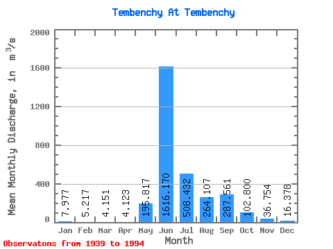
| Statistic | Jan | Feb | Mar | Apr | May | Jun | Jul | Aug | Sep | Oct | Nov | Dec | Annual |
|---|---|---|---|---|---|---|---|---|---|---|---|---|---|
| Mean | 7.98 | 5.22 | 4.15 | 4.12 | 195.82 | 1616.17 | 508.43 | 264.11 | 287.56 | 102.80 | 36.75 | 16.38 | 252.73 |
| Standard Deviation | 4.85 | 3.31 | 2.83 | 2.73 | 156.22 | 352.11 | 291.43 | 159.65 | 142.16 | 62.63 | 20.88 | 9.29 | 38.63 |
| Min | 0.63 | 0.29 | 0.27 | 0.35 | 9.90 | 1020.00 | 166.00 | 43.10 | 55.30 | 17.50 | 13.30 | 4.08 | 181.49 |
| Max | 18.60 | 13.40 | 10.70 | 9.57 | 564.00 | 2440.00 | 1360.00 | 838.00 | 615.00 | 270.00 | 120.00 | 38.80 | 346.13 |
| Coefficient of Variation | 0.61 | 0.64 | 0.68 | 0.66 | 0.80 | 0.22 | 0.57 | 0.60 | 0.49 | 0.61 | 0.57 | 0.57 | 0.15 |
 Return to R-Arctic Net Home Page