|
|
|||||||||||||||||
| Point ID: 6629 | Downloads | Plots | Site Data | Code: 9419 |
|
|
|||||||||||||||||
| Download | |
|---|---|
| Site Descriptor Information | Site Time Series Data |
| Link to all available data | |
| View: | Time Series | All |
| Units: | m3/s |
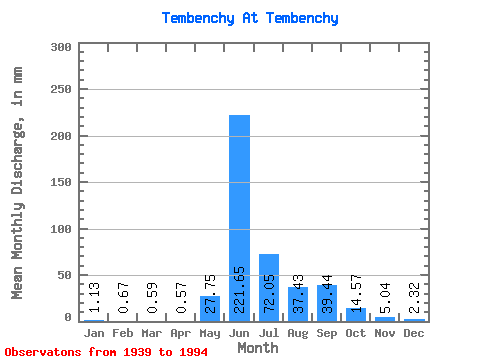
| Statistic | Jan | Feb | Mar | Apr | May | Jun | Jul | Aug | Sep | Oct | Nov | Dec | Annual |
|---|---|---|---|---|---|---|---|---|---|---|---|---|---|
| Mean | 1.13 | 0.67 | 0.59 | 0.56 | 27.75 | 221.65 | 72.04 | 37.42 | 39.44 | 14.57 | 5.04 | 2.32 | 422.01 |
| Standard Deviation | 0.69 | 0.43 | 0.40 | 0.38 | 22.14 | 48.29 | 41.29 | 22.62 | 19.50 | 8.87 | 2.86 | 1.32 | 64.51 |
| Min | 0.09 | 0.04 | 0.04 | 0.05 | 1.40 | 139.89 | 23.52 | 6.11 | 7.58 | 2.48 | 1.82 | 0.58 | 303.06 |
| Max | 2.63 | 1.73 | 1.52 | 1.31 | 79.92 | 334.63 | 192.70 | 118.74 | 84.34 | 38.26 | 16.46 | 5.50 | 577.98 |
| Coefficient of Variation | 0.61 | 0.64 | 0.68 | 0.66 | 0.80 | 0.22 | 0.57 | 0.60 | 0.49 | 0.61 | 0.57 | 0.57 | 0.15 |
 Return to R-Arctic Net Home Page