|
|
|||||||||||||||||
| Point ID: 6623 | Downloads | Plots | Site Data | Code: 9406 |
|
|
|||||||||||||||||
| Download | |
|---|---|
| Site Descriptor Information | Site Time Series Data |
| Link to all available data | |
| View: | Time Series | All |
| Units: | mm |
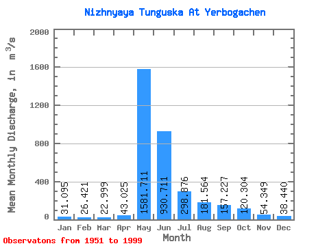
| Statistic | Jan | Feb | Mar | Apr | May | Jun | Jul | Aug | Sep | Oct | Nov | Dec | Annual |
|---|---|---|---|---|---|---|---|---|---|---|---|---|---|
| Mean | 31.09 | 26.42 | 23.00 | 43.02 | 1581.71 | 930.71 | 298.88 | 181.56 | 157.23 | 120.30 | 54.35 | 38.44 | 290.23 |
| Standard Deviation | 11.24 | 10.56 | 9.43 | 98.69 | 379.67 | 542.79 | 159.21 | 149.34 | 61.23 | 60.74 | 20.35 | 13.95 | 60.05 |
| Min | 14.90 | 8.54 | 5.30 | 8.17 | 731.00 | 230.00 | 80.00 | 55.50 | 65.50 | 43.40 | 18.60 | 17.70 | 177.86 |
| Max | 62.70 | 53.20 | 52.90 | 682.00 | 2300.00 | 2600.00 | 767.00 | 992.00 | 318.00 | 394.00 | 111.00 | 71.90 | 417.29 |
| Coefficient of Variation | 0.36 | 0.40 | 0.41 | 2.29 | 0.24 | 0.58 | 0.53 | 0.82 | 0.39 | 0.51 | 0.37 | 0.36 | 0.21 |
 Return to R-Arctic Net Home Page