|
|
|||||||||||||||||
| Point ID: 6623 | Downloads | Plots | Site Data | Code: 9406 |
|
|
|||||||||||||||||
| Download | |
|---|---|
| Site Descriptor Information | Site Time Series Data |
| Link to all available data | |
| View: | Time Series | All |
| Units: | m3/s |
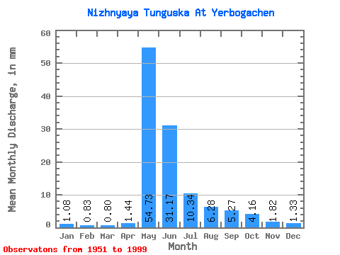
| Statistic | Jan | Feb | Mar | Apr | May | Jun | Jul | Aug | Sep | Oct | Nov | Dec | Annual |
|---|---|---|---|---|---|---|---|---|---|---|---|---|---|
| Mean | 1.08 | 0.83 | 0.80 | 1.44 | 54.73 | 31.17 | 10.34 | 6.28 | 5.26 | 4.16 | 1.82 | 1.33 | 118.34 |
| Standard Deviation | 0.39 | 0.33 | 0.33 | 3.31 | 13.14 | 18.18 | 5.51 | 5.17 | 2.05 | 2.10 | 0.68 | 0.48 | 24.49 |
| Min | 0.52 | 0.27 | 0.18 | 0.27 | 25.29 | 7.70 | 2.77 | 1.92 | 2.19 | 1.50 | 0.62 | 0.61 | 72.52 |
| Max | 2.17 | 1.68 | 1.83 | 22.84 | 79.58 | 87.07 | 26.54 | 34.32 | 10.65 | 13.63 | 3.72 | 2.49 | 170.15 |
| Coefficient of Variation | 0.36 | 0.40 | 0.41 | 2.29 | 0.24 | 0.58 | 0.53 | 0.82 | 0.39 | 0.51 | 0.37 | 0.36 | 0.21 |
 Return to R-Arctic Net Home Page