|
|
|||||||||||||||||
| Point ID: 6617 | Downloads | Plots | Site Data | Code: 9393 |
|
|
|||||||||||||||||
| Download | |
|---|---|
| Site Descriptor Information | Site Time Series Data |
| Link to all available data | |
| View: | Time Series | All |
| Units: | mm |
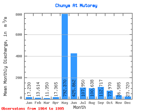
| Statistic | Jan | Feb | Mar | Apr | May | Jun | Jul | Aug | Sep | Oct | Nov | Dec | Annual |
|---|---|---|---|---|---|---|---|---|---|---|---|---|---|
| Mean | 17.23 | 13.61 | 11.35 | 17.36 | 792.37 | 425.86 | 107.95 | 100.64 | 112.72 | 77.97 | 36.59 | 23.72 | 141.34 |
| Standard Deviation | 8.14 | 5.99 | 4.61 | 20.27 | 244.31 | 303.51 | 70.86 | 105.31 | 95.72 | 71.83 | 23.74 | 13.03 | 46.35 |
| Min | 6.41 | 5.92 | 5.12 | 5.84 | 475.00 | 141.00 | 1.95 | 22.60 | 23.70 | 13.30 | 11.40 | 8.68 | 84.56 |
| Max | 37.90 | 30.40 | 24.90 | 114.00 | 1460.00 | 1460.00 | 271.00 | 465.00 | 402.00 | 322.00 | 108.00 | 65.90 | 267.30 |
| Coefficient of Variation | 0.47 | 0.44 | 0.41 | 1.17 | 0.31 | 0.71 | 0.66 | 1.05 | 0.85 | 0.92 | 0.65 | 0.55 | 0.33 |
 Return to R-Arctic Net Home Page