|
|
|||||||||||||||||
| Point ID: 6617 | Downloads | Plots | Site Data | Code: 9393 |
|
|
|||||||||||||||||
| Download | |
|---|---|
| Site Descriptor Information | Site Time Series Data |
| Link to all available data | |
| View: | Time Series | All |
| Units: | m3/s |
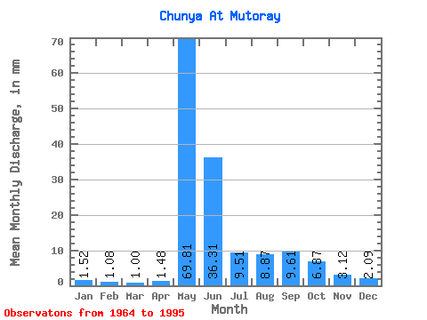
| Statistic | Jan | Feb | Mar | Apr | May | Jun | Jul | Aug | Sep | Oct | Nov | Dec | Annual |
|---|---|---|---|---|---|---|---|---|---|---|---|---|---|
| Mean | 1.52 | 1.09 | 1.00 | 1.48 | 69.80 | 36.31 | 9.51 | 8.87 | 9.61 | 6.87 | 3.12 | 2.09 | 146.74 |
| Standard Deviation | 0.72 | 0.48 | 0.41 | 1.73 | 21.52 | 25.88 | 6.24 | 9.28 | 8.16 | 6.33 | 2.02 | 1.15 | 48.12 |
| Min | 0.56 | 0.47 | 0.45 | 0.50 | 41.84 | 12.02 | 0.17 | 1.99 | 2.02 | 1.17 | 0.97 | 0.77 | 87.79 |
| Max | 3.34 | 2.44 | 2.19 | 9.72 | 128.61 | 124.48 | 23.87 | 40.96 | 34.28 | 28.37 | 9.21 | 5.80 | 277.50 |
| Coefficient of Variation | 0.47 | 0.44 | 0.41 | 1.17 | 0.31 | 0.71 | 0.66 | 1.05 | 0.85 | 0.92 | 0.65 | 0.55 | 0.33 |
 Return to R-Arctic Net Home Page