|
|
|||||||||||||||||
| Point ID: 6606 | Downloads | Plots | Site Data | Code: 9372 |
|
|
|||||||||||||||||
| Download | |
|---|---|
| Site Descriptor Information | Site Time Series Data |
| Link to all available data | |
| View: | Time Series | All |
| Units: | mm |
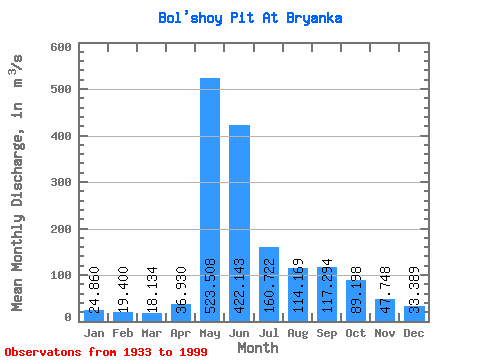
| Statistic | Jan | Feb | Mar | Apr | May | Jun | Jul | Aug | Sep | Oct | Nov | Dec | Annual |
|---|---|---|---|---|---|---|---|---|---|---|---|---|---|
| Mean | 24.86 | 19.40 | 18.13 | 36.93 | 523.51 | 422.14 | 160.72 | 114.17 | 117.29 | 89.20 | 47.75 | 33.39 | 134.23 |
| Standard Deviation | 8.31 | 6.82 | 6.46 | 40.24 | 119.83 | 175.72 | 51.20 | 52.89 | 54.91 | 40.68 | 20.17 | 13.02 | 25.53 |
| Min | 3.58 | 3.04 | 3.33 | 6.29 | 256.00 | 189.00 | 87.70 | 47.80 | 48.70 | 32.70 | 14.00 | 5.80 | 88.18 |
| Max | 44.50 | 38.50 | 31.90 | 245.00 | 788.00 | 1110.00 | 291.00 | 334.00 | 311.00 | 229.00 | 97.50 | 68.10 | 210.30 |
| Coefficient of Variation | 0.33 | 0.35 | 0.36 | 1.09 | 0.23 | 0.42 | 0.32 | 0.46 | 0.47 | 0.46 | 0.42 | 0.39 | 0.19 |
 Return to R-Arctic Net Home Page