|
|
|||||||||||||||||
| Point ID: 6606 | Downloads | Plots | Site Data | Code: 9372 |
|
|
|||||||||||||||||
| Download | |
|---|---|
| Site Descriptor Information | Site Time Series Data |
| Link to all available data | |
| View: | Time Series | All |
| Units: | m3/s |
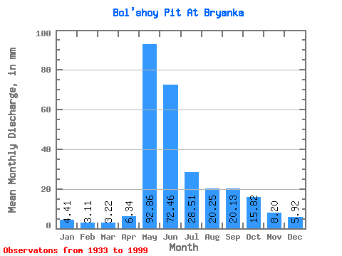
| Statistic | Jan | Feb | Mar | Apr | May | Jun | Jul | Aug | Sep | Oct | Nov | Dec | Annual |
|---|---|---|---|---|---|---|---|---|---|---|---|---|---|
| Mean | 4.41 | 3.13 | 3.22 | 6.34 | 92.84 | 72.46 | 28.50 | 20.25 | 20.13 | 15.82 | 8.20 | 5.92 | 280.56 |
| Standard Deviation | 1.47 | 1.10 | 1.15 | 6.91 | 21.25 | 30.16 | 9.08 | 9.38 | 9.43 | 7.21 | 3.46 | 2.31 | 53.35 |
| Min | 0.64 | 0.49 | 0.59 | 1.08 | 45.40 | 32.44 | 15.55 | 8.48 | 8.36 | 5.80 | 2.40 | 1.03 | 184.31 |
| Max | 7.89 | 6.22 | 5.66 | 42.06 | 139.75 | 190.54 | 51.61 | 59.23 | 53.38 | 40.61 | 16.74 | 12.08 | 439.54 |
| Coefficient of Variation | 0.33 | 0.35 | 0.36 | 1.09 | 0.23 | 0.42 | 0.32 | 0.46 | 0.47 | 0.46 | 0.42 | 0.39 | 0.19 |
 Return to R-Arctic Net Home Page