|
|
|||||||||||||||||
| Point ID: 6604 | Downloads | Plots | Site Data | Code: 9368 |
|
|
|||||||||||||||||
| Download | |
|---|---|
| Site Descriptor Information | Site Time Series Data |
| Link to all available data | |
| View: | Time Series | All |
| Units: | mm |
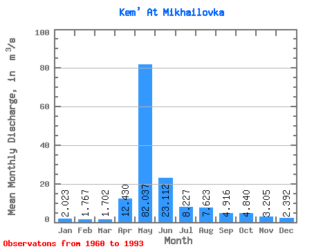
| Statistic | Jan | Feb | Mar | Apr | May | Jun | Jul | Aug | Sep | Oct | Nov | Dec | Annual |
|---|---|---|---|---|---|---|---|---|---|---|---|---|---|
| Mean | 2.02 | 1.77 | 1.70 | 12.43 | 82.04 | 23.11 | 8.23 | 7.62 | 4.92 | 4.84 | 3.21 | 2.39 | 12.86 |
| Standard Deviation | 0.47 | 0.40 | 0.47 | 13.19 | 34.36 | 13.28 | 9.54 | 13.27 | 2.55 | 2.32 | 1.05 | 0.61 | 4.50 |
| Min | 1.20 | 1.04 | 0.90 | 1.09 | 20.50 | 5.85 | 3.22 | 2.45 | 2.09 | 2.31 | 1.86 | 1.37 | 6.41 |
| Max | 3.18 | 2.57 | 2.57 | 43.50 | 188.00 | 52.10 | 54.90 | 75.70 | 12.10 | 11.00 | 5.42 | 3.86 | 26.68 |
| Coefficient of Variation | 0.23 | 0.23 | 0.27 | 1.06 | 0.42 | 0.57 | 1.16 | 1.74 | 0.52 | 0.48 | 0.33 | 0.25 | 0.35 |
 Return to R-Arctic Net Home Page