|
|
|||||||||||||||||
| Point ID: 6604 | Downloads | Plots | Site Data | Code: 9368 |
|
|
|||||||||||||||||
| Download | |
|---|---|
| Site Descriptor Information | Site Time Series Data |
| Link to all available data | |
| View: | Time Series | All |
| Units: | m3/s |
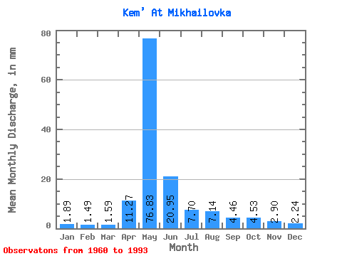
| Statistic | Jan | Feb | Mar | Apr | May | Jun | Jul | Aug | Sep | Oct | Nov | Dec | Annual |
|---|---|---|---|---|---|---|---|---|---|---|---|---|---|
| Mean | 1.89 | 1.51 | 1.59 | 11.27 | 76.82 | 20.95 | 7.70 | 7.14 | 4.46 | 4.53 | 2.91 | 2.24 | 141.87 |
| Standard Deviation | 0.44 | 0.34 | 0.43 | 11.96 | 32.17 | 12.04 | 8.93 | 12.43 | 2.31 | 2.17 | 0.95 | 0.57 | 49.72 |
| Min | 1.12 | 0.89 | 0.84 | 0.99 | 19.20 | 5.30 | 3.02 | 2.29 | 1.89 | 2.16 | 1.69 | 1.28 | 70.75 |
| Max | 2.98 | 2.19 | 2.41 | 39.42 | 176.04 | 47.22 | 51.41 | 70.88 | 10.97 | 10.30 | 4.91 | 3.61 | 294.42 |
| Coefficient of Variation | 0.23 | 0.23 | 0.27 | 1.06 | 0.42 | 0.57 | 1.16 | 1.74 | 0.52 | 0.48 | 0.33 | 0.25 | 0.35 |
 Return to R-Arctic Net Home Page