|
|
|||||||||||||||||
| Point ID: 6600 | Downloads | Plots | Site Data | Code: 9346 |
|
|
|||||||||||||||||
| Download | |
|---|---|
| Site Descriptor Information | Site Time Series Data |
| Link to all available data | |
| View: | Time Series | All |
| Units: | mm |
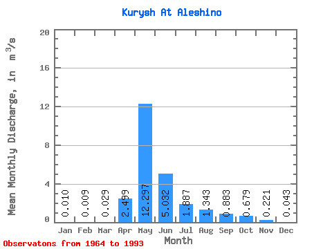
| Statistic | Jan | Feb | Mar | Apr | May | Jun | Jul | Aug | Sep | Oct | Nov | Dec | Annual |
|---|---|---|---|---|---|---|---|---|---|---|---|---|---|
| Mean | 0.01 | 0.01 | 0.03 | 2.50 | 12.30 | 5.03 | 1.89 | 1.34 | 0.88 | 0.68 | 0.22 | 0.04 | 2.04 |
| Standard Deviation | 0.02 | 0.02 | 0.04 | 2.08 | 6.25 | 2.38 | 1.08 | 1.32 | 0.54 | 0.40 | 0.18 | 0.05 | 1.26 |
| Min | 0.00 | 0.00 | 0.00 | 0.16 | 4.23 | 1.58 | 0.64 | 0.29 | 0.21 | 0.13 | 0.02 | 0.00 | 0.91 |
| Max | 0.09 | 0.05 | 0.07 | 9.05 | 32.90 | 10.70 | 4.32 | 5.72 | 2.01 | 1.62 | 0.62 | 0.19 | 4.11 |
| Coefficient of Variation | 1.96 | 2.45 | 1.25 | 0.83 | 0.51 | 0.47 | 0.57 | 0.98 | 0.61 | 0.60 | 0.82 | 1.23 | 0.62 |
 Return to R-Arctic Net Home Page