|
|
|||||||||||||||||
| Point ID: 6600 | Downloads | Plots | Site Data | Code: 9346 |
|
|
|||||||||||||||||
| Download | |
|---|---|
| Site Descriptor Information | Site Time Series Data |
| Link to all available data | |
| View: | Time Series | All |
| Units: | m3/s |
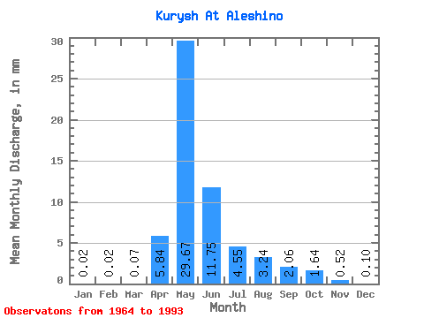
| Statistic | Jan | Feb | Mar | Apr | May | Jun | Jul | Aug | Sep | Oct | Nov | Dec | Annual |
|---|---|---|---|---|---|---|---|---|---|---|---|---|---|
| Mean | 0.02 | 0.02 | 0.07 | 5.84 | 29.67 | 11.75 | 4.55 | 3.24 | 2.06 | 1.64 | 0.52 | 0.10 | 58.06 |
| Standard Deviation | 0.05 | 0.05 | 0.09 | 4.85 | 15.07 | 5.56 | 2.61 | 3.18 | 1.25 | 0.97 | 0.42 | 0.13 | 35.83 |
| Min | 0.00 | 0.00 | 0.00 | 0.37 | 10.21 | 3.69 | 1.54 | 0.70 | 0.49 | 0.31 | 0.04 | 0.00 | 25.92 |
| Max | 0.21 | 0.12 | 0.17 | 21.13 | 79.38 | 24.99 | 10.42 | 13.80 | 4.69 | 3.91 | 1.45 | 0.46 | 116.94 |
| Coefficient of Variation | 1.96 | 2.45 | 1.25 | 0.83 | 0.51 | 0.47 | 0.57 | 0.98 | 0.61 | 0.60 | 0.82 | 1.23 | 0.62 |
 Return to R-Arctic Net Home Page