|
|
|||||||||||||||||
| Point ID: 6598 | Downloads | Plots | Site Data | Code: 9343 |
|
|
|||||||||||||||||
| Download | |
|---|---|
| Site Descriptor Information | Site Time Series Data |
| Link to all available data | |
| View: | Time Series | All |
| Units: | mm |
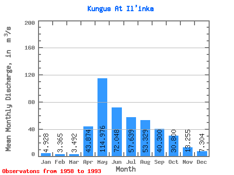
| Statistic | Jan | Feb | Mar | Apr | May | Jun | Jul | Aug | Sep | Oct | Nov | Dec | Annual |
|---|---|---|---|---|---|---|---|---|---|---|---|---|---|
| Mean | 4.93 | 3.37 | 3.49 | 43.87 | 114.98 | 72.05 | 57.64 | 53.33 | 40.30 | 30.80 | 13.26 | 7.30 | 37.11 |
| Standard Deviation | 1.78 | 1.45 | 1.55 | 26.32 | 54.20 | 28.12 | 20.25 | 34.77 | 16.47 | 13.42 | 5.26 | 2.79 | 9.52 |
| Min | 1.09 | 0.93 | 0.73 | 8.15 | 44.90 | 37.80 | 26.20 | 9.86 | 11.90 | 11.00 | 6.30 | 1.88 | 19.61 |
| Max | 8.22 | 5.95 | 6.83 | 107.00 | 267.00 | 132.00 | 134.00 | 190.00 | 76.00 | 63.30 | 25.20 | 13.50 | 59.72 |
| Coefficient of Variation | 0.36 | 0.43 | 0.44 | 0.60 | 0.47 | 0.39 | 0.35 | 0.65 | 0.41 | 0.44 | 0.40 | 0.38 | 0.26 |
 Return to R-Arctic Net Home Page