|
|
|||||||||||||||||
| Point ID: 6598 | Downloads | Plots | Site Data | Code: 9343 |
|
|
|||||||||||||||||
| Download | |
|---|---|
| Site Descriptor Information | Site Time Series Data |
| Link to all available data | |
| View: | Time Series | All |
| Units: | m3/s |
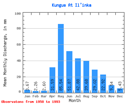
| Statistic | Jan | Feb | Mar | Apr | May | Jun | Jul | Aug | Sep | Oct | Nov | Dec | Annual |
|---|---|---|---|---|---|---|---|---|---|---|---|---|---|
| Mean | 3.67 | 2.28 | 2.60 | 31.59 | 85.53 | 51.88 | 42.88 | 39.67 | 29.02 | 22.91 | 9.54 | 5.43 | 325.32 |
| Standard Deviation | 1.33 | 0.98 | 1.15 | 18.95 | 40.32 | 20.25 | 15.07 | 25.86 | 11.86 | 9.98 | 3.79 | 2.08 | 83.48 |
| Min | 0.81 | 0.63 | 0.54 | 5.87 | 33.40 | 27.22 | 19.49 | 7.33 | 8.57 | 8.18 | 4.54 | 1.40 | 171.88 |
| Max | 6.12 | 4.03 | 5.08 | 77.04 | 198.62 | 95.04 | 99.68 | 141.34 | 54.72 | 47.09 | 18.14 | 10.04 | 523.54 |
| Coefficient of Variation | 0.36 | 0.43 | 0.44 | 0.60 | 0.47 | 0.39 | 0.35 | 0.65 | 0.41 | 0.44 | 0.40 | 0.38 | 0.26 |
 Return to R-Arctic Net Home Page