|
|
|||||||||||||||||
| Point ID: 6590 | Downloads | Plots | Site Data | Code: 9326 |
|
|
|||||||||||||||||
| Download | |
|---|---|
| Site Descriptor Information | Site Time Series Data |
| Link to all available data | |
| View: | Time Series | All |
| Units: | mm |
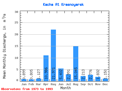
| Statistic | Jan | Feb | Mar | Apr | May | Jun | Jul | Aug | Sep | Oct | Nov | Dec | Annual |
|---|---|---|---|---|---|---|---|---|---|---|---|---|---|
| Mean | 0.90 | 0.81 | 1.13 | 10.99 | 21.97 | 5.40 | 2.99 | 15.04 | 2.21 | 2.78 | 1.83 | 1.15 | 5.62 |
| Standard Deviation | 0.38 | 0.30 | 0.56 | 6.26 | 6.50 | 2.21 | 2.69 | 52.57 | 0.94 | 1.08 | 0.82 | 0.52 | 4.42 |
| Min | 0.43 | 0.39 | 0.61 | 3.59 | 10.50 | 1.84 | 1.30 | 0.99 | 0.90 | 1.21 | 0.74 | 0.50 | 3.18 |
| Max | 1.72 | 1.50 | 2.32 | 26.40 | 32.30 | 9.71 | 12.70 | 219.00 | 3.89 | 4.75 | 3.54 | 2.32 | 22.30 |
| Coefficient of Variation | 0.42 | 0.37 | 0.49 | 0.57 | 0.30 | 0.41 | 0.90 | 3.49 | 0.42 | 0.39 | 0.45 | 0.45 | 0.79 |
 Return to R-Arctic Net Home Page