|
|
|||||||||||||||||
| Point ID: 6590 | Downloads | Plots | Site Data | Code: 9326 |
|
|
|||||||||||||||||
| Download | |
|---|---|
| Site Descriptor Information | Site Time Series Data |
| Link to all available data | |
| View: | Time Series | All |
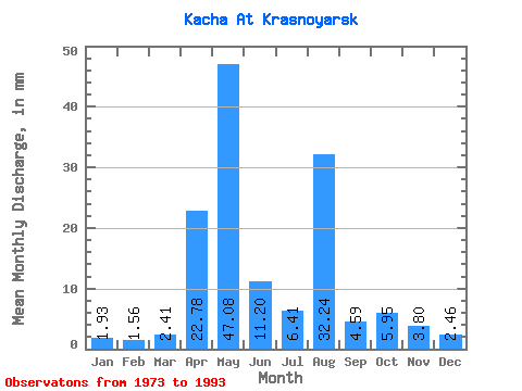
| Units: | m3/s |
| Statistic | Jan | Feb | Mar | Apr | May | Jun | Jul | Aug | Sep | Oct | Nov | Dec | Annual |
|---|---|---|---|---|---|---|---|---|---|---|---|---|---|
| Mean | 1.93 | 1.57 | 2.42 | 22.78 | 47.07 | 11.20 | 6.41 | 32.23 | 4.59 | 5.95 | 3.80 | 2.46 | 141.85 |
| Standard Deviation | 0.82 | 0.59 | 1.19 | 12.98 | 13.93 | 4.59 | 5.77 | 112.63 | 1.94 | 2.32 | 1.70 | 1.11 | 111.66 |
| Min | 0.92 | 0.76 | 1.31 | 7.44 | 22.50 | 3.81 | 2.79 | 2.12 | 1.87 | 2.59 | 1.53 | 1.07 | 80.20 |
| Max | 3.69 | 2.93 | 4.97 | 54.74 | 69.20 | 20.14 | 27.21 | 469.19 | 8.07 | 10.18 | 7.34 | 4.97 | 563.12 |
| Coefficient of Variation | 0.42 | 0.37 | 0.49 | 0.57 | 0.30 | 0.41 | 0.90 | 3.49 | 0.42 | 0.39 | 0.45 | 0.45 | 0.79 |
 Return to R-Arctic Net Home Page