|
|
|||||||||||||||||
| Point ID: 6589 | Downloads | Plots | Site Data | Code: 9324 |
|
|
|||||||||||||||||
| Download | |
|---|---|
| Site Descriptor Information | Site Time Series Data |
| Link to all available data | |
| View: | Time Series | All |
| Units: | mm |
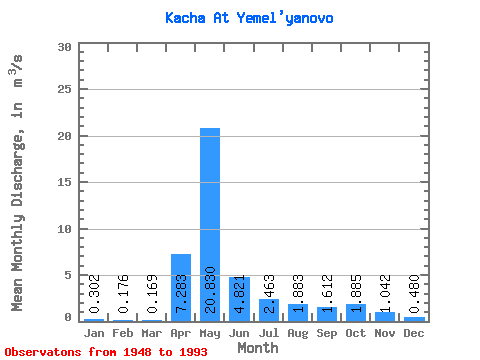
| Statistic | Jan | Feb | Mar | Apr | May | Jun | Jul | Aug | Sep | Oct | Nov | Dec | Annual |
|---|---|---|---|---|---|---|---|---|---|---|---|---|---|
| Mean | 0.30 | 0.18 | 0.17 | 7.28 | 20.83 | 4.82 | 2.46 | 1.88 | 1.61 | 1.89 | 1.04 | 0.48 | 3.65 |
| Standard Deviation | 0.30 | 0.22 | 0.28 | 4.65 | 7.59 | 2.33 | 2.28 | 1.68 | 0.85 | 1.06 | 0.62 | 0.33 | 0.88 |
| Min | 0.02 | 0.00 | 0.00 | 0.70 | 8.57 | 1.24 | 0.63 | 0.54 | 0.51 | 0.62 | 0.29 | 0.09 | 2.04 |
| Max | 1.65 | 0.90 | 1.43 | 18.00 | 42.70 | 10.60 | 11.20 | 8.59 | 3.75 | 4.38 | 3.27 | 1.58 | 5.59 |
| Coefficient of Variation | 1.01 | 1.25 | 1.68 | 0.64 | 0.36 | 0.48 | 0.93 | 0.89 | 0.53 | 0.56 | 0.59 | 0.68 | 0.24 |
 Return to R-Arctic Net Home Page