|
|
|||||||||||||||||
| Point ID: 6589 | Downloads | Plots | Site Data | Code: 9324 |
|
|
|||||||||||||||||
| Download | |
|---|---|
| Site Descriptor Information | Site Time Series Data |
| Link to all available data | |
| View: | Time Series | All |
| Units: | m3/s |
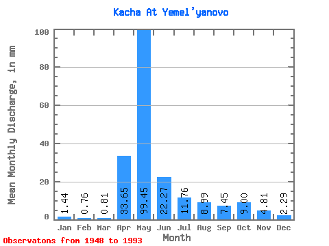
| Statistic | Jan | Feb | Mar | Apr | May | Jun | Jul | Aug | Sep | Oct | Nov | Dec | Annual |
|---|---|---|---|---|---|---|---|---|---|---|---|---|---|
| Mean | 1.44 | 0.77 | 0.81 | 33.65 | 99.43 | 22.27 | 11.76 | 8.99 | 7.45 | 9.00 | 4.82 | 2.29 | 205.59 |
| Standard Deviation | 1.45 | 0.95 | 1.35 | 21.48 | 36.22 | 10.76 | 10.90 | 8.01 | 3.94 | 5.05 | 2.85 | 1.57 | 49.44 |
| Min | 0.09 | 0.00 | 0.00 | 3.23 | 40.91 | 5.73 | 3.01 | 2.58 | 2.36 | 2.96 | 1.34 | 0.41 | 114.92 |
| Max | 7.88 | 3.91 | 6.83 | 83.17 | 203.83 | 48.98 | 53.47 | 41.01 | 17.33 | 20.91 | 15.11 | 7.54 | 314.52 |
| Coefficient of Variation | 1.01 | 1.25 | 1.68 | 0.64 | 0.36 | 0.48 | 0.93 | 0.89 | 0.53 | 0.56 | 0.59 | 0.68 | 0.24 |
 Return to R-Arctic Net Home Page