|
|
|||||||||||||||||
| Point ID: 6580 | Downloads | Plots | Site Data | Code: 9279 |
|
|
|||||||||||||||||
| Download | |
|---|---|
| Site Descriptor Information | Site Time Series Data |
| Link to all available data | |
| View: | Time Series | All |
| Units: | mm |
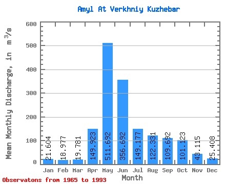
| Statistic | Jan | Feb | Mar | Apr | May | Jun | Jul | Aug | Sep | Oct | Nov | Dec | Annual |
|---|---|---|---|---|---|---|---|---|---|---|---|---|---|
| Mean | 21.60 | 18.98 | 19.78 | 149.92 | 511.69 | 356.69 | 149.18 | 122.33 | 109.69 | 101.12 | 43.12 | 25.41 | 135.79 |
| Standard Deviation | 4.24 | 2.61 | 3.60 | 68.23 | 134.44 | 187.11 | 58.59 | 52.99 | 55.25 | 49.87 | 17.28 | 5.75 | 25.76 |
| Min | 14.30 | 15.50 | 14.20 | 25.30 | 290.00 | 132.00 | 56.50 | 36.10 | 51.50 | 41.90 | 24.20 | 14.00 | 89.10 |
| Max | 30.10 | 25.70 | 29.10 | 270.00 | 822.00 | 903.00 | 305.00 | 215.00 | 310.00 | 252.00 | 82.70 | 38.40 | 192.88 |
| Coefficient of Variation | 0.20 | 0.14 | 0.18 | 0.46 | 0.26 | 0.53 | 0.39 | 0.43 | 0.50 | 0.49 | 0.40 | 0.23 | 0.19 |
 Return to R-Arctic Net Home Page